Hidden Gems
Jefferson Barracks
Reporting by Valerie Schremp Hahn. Design and development by Andrew Nguyen. Photos by Cristina M. Fletes.
Think the Arch is the gateway to the west? Look about 11 miles south, and think about Jefferson Barracks.
The area was established in 1826 as a military post to replace the aging Fort Belle Fontaine, and just about any soldier from the military effort in the western half of the United States passed through here.

“Being founded in 1826 and being involved in every major military event through the present day — that’s pretty phenomenal,” said John Magurany, cultural site manager for Jefferson Barracks County Park.
The installation itself once spread across more than 1,700 acres; Jefferson Barracks Park, established in 1950, is 426 acres. It’s no accident that the Jefferson Barracks National Cemetery, the Veterans Administration hospital and Sylvan Springs Park — also part of barracks history — are also nearby.

Jefferson Barracks Park is home to a disc golf course, an amphitheater for concerts, a community center and pool, an archery range and more than nine miles of paved trails. It’s also home to several historic museums.
Though it was deactivated as a military post in 1946, the Missouri Air National Guard and the Missouri Army National Guard still operate from the site.
The buildings and grounds tell an obvious history, and some tucked-away corners tell more.
Other Hidden Gems
Location #1
Sylvan Springs

The history of Jefferson Barracks physically starts here, at the actual spring where Cmdr. Stephen Watts Kearny camped with his troops on July 10, 1826, two days after a deed was signed to establish an infantry school. More than a century later, public workers built a beer garden at the spring, complete with stone bridges and terraces. Little details are still visible: the initials “JB” at the end of a staircase, relief carvings of squirrels and decorative drainage holes. “As much as people may know about this, it’s the details they don’t look at,” said Magurany. The area was always set aside to serve as a park for the military, and a natural amphitheater nearby held World War II troops that watched performances by Judy Garland, Bob Hope, Danny Kaye and a boxing match between Joe Lewis and Billy Conn. The spring is now part of Sylvan Springs Park, which is its own park because it’s not contiguous to Jefferson Barracks Park.
Location #2
Old Powder Depot gate

A gate leading to an overlook was once made of four U.S. Army cannons, and a fence of deactivated Civil War rifle barrels from the St. Louis Arsenal, just south of downtown. The gate once led to the powder depot headquarters. You can still see bayonets topping some of the barrels, and some pieces are broken off (Magurany has heard from older park visitors who confessed to breaking off the barrels as kids). The fence used to stretch farther, but the parts were scrapped during World War II. A bus driver once heavily damaged the gate entrance about 20 years ago by attempting to drive a too-tall bus through it. Last year, the park fixed it, adding a replica of the insignia of the U.S. Army Ordnance Department over the gate. The original insignia can be seen in the Powder Magazine Museum, along with the oldest item in the park: a Jefferson Barracks display stone from 1827.
Location #3
No. 1 garage

A building now known as the No. 1 garage, near some gas pumps just off CCC Road, was built as a powder magazine. It’s now storage for junk and supplies and has a barrel-vaulted ceiling. Like the Powder Magazine Museum and the Old Ordnance Room, the vaults were meant to fall down and extinguish a fire in the event of an attack or accident. A stone above a doorway is etched with the date “AD 1866,” and a manhole on the floor leads to a cave. Inside, you can see a giant archway that’s been blocked by stone. Magurany says there’s an urban legend that the archway blocks a tunnel that leads to the site of the ordnance commander’s house, which no longer stands. “Just to open it is creepy,” he said of the manhole.
Location #4
Stone foundations and 'Pneumonia Gulch'

About 20 concrete foundations are visible throughout the park, mostly in the woods, some visible from walking trails and roads. They supported wooden structures built for World War II officers. Foundations down by the river were once intake centers, where soldiers getting off trains got their uniforms and had medical checks. Foundations in the woods closer to the present-day disc golf course and Lemay Pavilion were living quarters and offices for higher-ranking officials. Soldiers stayed in hutments, or wooden platforms equipped with a tent. Sinkholes in the area collected water, and soldiers often got sick with respiratory infections, giving that area the nickname “Pneumonia Gulch.” Near one swampy spot, a rusty axle from a military vehicle juts from the ground. The area is a popular gathering spot for deer.
Location #5
Quarry and William Clark campsite

Just behind the amphitheater and down a gravel service road leading to the Mississippi River, you’ll find a brush pile that doesn’t look like much. Behind it is a limestone cliff where workers quarried stones to build the powder magazine and stone walls. At least one drill mark is still visible, Magurany points out — that’s where workers would drill, insert a wooden peg and either ice or heat it from above to expand the peg to split open the rock. The quarry faces the Mississippi River, and explorer William Clark passed by here in December 1803 on his way to Cahokia to meet Meriwether Lewis. Just downstream from the site, the wind picked up and took off a mast, possibly from his keelboat. Clark eventually went past Carondelet and to Cahokia.
Location #6
Laborer’s House gardens and fruit cellar

The Laborer’s House isn’t necessarily hidden, considering it’s next to the visitors center, stone stables and Powder Magazine Museum, common sites in the park. But look closely at the gardens behind it: the stone foundations for walls and a privy once supported a summer kitchen for the Laborer’s House. The park hadn’t known about the kitchen until they acquired an old photo, and then student archaeologists excavated the foundations in the 1950s. Behind the Laborer’s House in a patch of woods is an underground fruit cellar, probably used by those who lived in the house. The stone walls, marked with graffiti, support a vaulted ceiling. A metal gate installed years ago blocks anyone from going in, but you can peek.
Location #7
North entrance with alligator insignia

Two recently restored guard shacks and a building at the north entrance of the park were used by military police during World War II. The buildings are easily visible as you drive by, but if you pull over to take a closer look you’ll see the Coat of Arms of the 6th Infantry above the door. It features a green alligator, which represents the service of the regiment during the Seminole War of 1837. A green ladder underneath represents the storming of the Citadel of Chapultepec in Mexico in 1847. The streetcar line once passed by here, along Gregg Road. During World War II, German owners of nearby bars in Lemay got permission to employ some of the German POWs to work for them. The barracks housed nearly 500 POWs from Germany. They were sent back home at the end of the war, though seven German and Italian POWs who died locally are buried at the cemetery. Some of their pictures and artwork, including carvings of baskets and a squirrel out of peach pits, are on display at the Powder Magazine Museum.
Location #8
Spanish naval gun, sundial and swastika

The armored cruiser Oquendo of the Spanish Navy was sunk near Cuba during the Spanish-American War in 1898, and after the wreckage was raised one of the guns was put on this spot overlooking the Mississippi River, just behind Building One, an administration building. “Missourians get a kick out of the fact it’s pointed at Illinois,” points out Col. Bill Boothman, who works in the building as the 131st Mission Support Group Commander. You can’t get a close-up look at the spot unless you have permission, but it’s visible from the road. Next to the rare gun is an iron fence surrounding a sundial — this one is a replica of one that was stolen decades ago — with a winged hourglass on its face. Perhaps it was used to help keep time for the trains that brought troops to the station, which once stood below the site. Just below the sundial, you’ll see a swastika and the name “Belke” carved into the top of a stone wall. It may have been carved by a German POW.
Location #9
Building No. 1
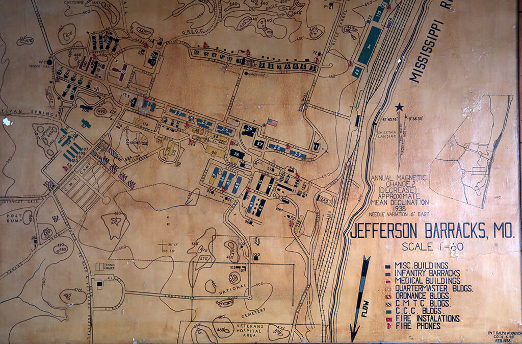
Constructed in 1900, the three-story administration building would traditionally have its front facing the parade grounds — and it does. But builders liked the view of the Mississippi River so much that they made the front look the same as the back, with windows facing the bluffs and passing barges. The building isn’t normally open to the public, and inside is a second-floor ballroom, which had been converted to a large meeting room with a drop ceiling until a few decades ago. Workers took the ceiling down, revealing beautiful wooden trusses. A large topographic map of Jefferson Barracks, painted by Pvt. Ralph V. Rausch in 1938, graces a back wall. It details locations of buildings long gone and even the sinkholes in the area of Pneumonia Gulch, though the nickname didn’t make the map.
Location #10
Nurse’s quarters and streetcar station

The nurse’s quarters building, which is not open to the public, was built in the late 1930s and is next to the Telephone Museum. St. Louis County Parks uses the building as a sign shop and for storage of archives, which includes shelves of military trunks (some with letters still inside), mannequins for museum displays, a variety of military uniforms, military saddles (Jefferson Barracks was the birthplace of the first cavalry division, the United States Regiment of Dragoons) and a collection of 80,000 military medals. Six nurses supposedly shared three beds in small dorm rooms, sleeping in them in shifts. A nondescript gray brick building behind the nurse’s quarters was once a streetcar station for a line that went along Gregg Road and into St. Louis.
1
2
3
4
5
6
7
8
9
10