Hidden Gems
Fort Belle Fontaine Park
Reporting by Valerie Schremp Hahn. Photos by Christine Tannous. Design and development by Andrew Nguyen
It was the first U.S. Military Installation west of the Mississippi River, built in 1805 to serve as a trading center and starting point for expeditions exploring the west.
Fort Belle Fontaine is now a St. Louis County park of just over 305 acres on the banks of the Missouri River north of Spanish Lake. There are no playgrounds or fancy amenities here, but there are about four miles of trails that lead through upland prairie, wetlands, a grand stone staircase and traces of its military history. It’s also a great place to spot eagles in the winter.
No battles were fought here, but famous explorers passed through: Meriwether Lewis, William Clark, Zebulon Pike, Henry Atkinson and others.
Cottages in the center of the property belong to the state, and are still in use as the Missouri Hills Youth Center for juvenile offenders. The cottages were built in the 1910s as a home for boys.

Floodwaters have recently covered part of the lower trail along Coldwater Creek and the Missouri River, but there’s still a lot to see. “This is probably one of the best-kept secrets in St. Louis County,” said cultural site manager John Magurany.
Magurany led us on a tour of its highlights and out-of-the-way spots.
Other Hidden Gems
Location #1
Belle Fontaine

Photo courtesy of the St. Louis County Department of Parks and Recreation.
There it is, along the bank of the Missouri River: the actual Belle Fontaine. That’s the French words for “beautiful fountain,” and the spring trickles to this day. In higher water, it’s not visible.
On July 23, 1805, Gen. James Wilkinson, who was the first governor of the newly acquired Louisiana Territory, selected the site as a fort and trading post for local tribes. He said the spring provided “pure water, competent to supply one thousand men daily.” That thinking only worked for so long, because damp conditions, mosquitoes and contaminated washing and cooking water from the river made the troops ill.
The spring itself is the namesake for other area places: Bellefontaine Road, Bellefontaine Cemetery, Bellefontaine Neighbors, Bellefontaine Automotive, Fontaine Estates.
Location #2
Original fort site
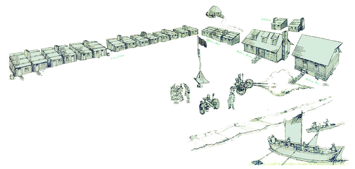
Illustration by Fred Padberg. Courtesy of the St. Louis County Department of Parks and Recreation.
Wilkinson’s fort and factory consisted of log buildings containing a blacksmith’s shop, a quartermaster’s store and homes for officers' families. Soldiers lived in tents that later had floors of hewn logs. This encampment spread along the riverbank for about 500 feet, and some well-known explorers stopped by this spot or near it.
Lewis and Clark camped on a river island near Coldwater Creek at the start of their expedition in 1804, before the fort was built, and stopped at the fort on the way back in 1806, on the final night of their journey. Clark wrote that they were “kindly received by the Gentlemen of this place.” Zebulon Pike started both his expeditions west from here in 1805 and 1806 while his wife and toddler son stayed behind. His son suffered one of the illnesses that killed so many troops and died here in November 1806, the same month his father discovered Pike’s Peak in Colorado.
Lt. Col. Daniel Bissell built a second fort on higher bluff ground in 1811, and the first fort was abandoned. (Bissel’s federal-style home, about five miles south on Bellefontaine Road, is also run by the county and open by appointment for tours.)
Erosion and shifts in the river’s path washed away the original fort site, and the spot sits under the Missouri River. There are two theories on its location, said Magurany: near the mouth of Coldwater Creek, or down the hill from the site of the second (1811) fort at the top off the bluff. It makes sense that when they moved the fort they just moved it directly up the bluff, he said.
Location #3
Original fort site
Illustration by Fred Padberg. Courtesy of the St. Louis County Department of Parks and Recreation.
Wilkinson’s fort and factory consisted of log buildings containing a blacksmith’s shop, a quartermaster’s store and homes for officers' families. Soldiers lived in tents that later had floors of hewn logs. This encampment spread along the riverbank for about 500 feet, and some well-known explorers stopped by this spot or near it.
Lewis and Clark camped on a river island near Coldwater Creek at the start of their expedition in 1804, before the fort was built, and stopped at the fort on the way back in 1806, on the final night of their journey. Clark wrote that they were “kindly received by the Gentlemen of this place.” Zebulon Pike started both his expeditions west from here in 1805 and 1806 while his wife and toddler son stayed behind. His son suffered one of the illnesses that killed so many troops and died here in November 1806, the same month his father discovered Pike’s Peak in Colorado.
Lt. Col. Daniel Bissell built a second fort on higher bluff ground in 1811, and the first fort was abandoned. (Bissel’s federal-style home, about five miles south on Bellefontaine Road, is also run by the county and open by appointment for tours.)
Erosion and shifts in the river’s path washed away the original fort site, and the spot sits under the Missouri River. There are two theories on its location, said Magurany: near the mouth of Coldwater Creek, or down the hill from the site of the second (1811) fort at the top off the bluff. It makes sense that when they moved the fort they just moved it directly up the bluff, he said.
Location #4
Giant’s Stone Seats and mill site

Photo courtesy of the St. Louis County Department of Parks and Recreation.
Rock formations at a bend of Coldwater Creek are known as the Giant’s Stone Seats and are visible when the water is at normal levels. Coldwater Creek flows through 15 miles of north St. Louis County, and the creek has made headlines because a federal investigation showed that people exposed to its waters from the 1960s to the 1990s are at a higher risk of some cancers because of nuclear waste contamination during World War II. Remediation efforts continue. A farmer named Hezekiah Lard built a mill at a bend of the creek before 1797, and no traces remain, though a low stone wall near the spot may have been a part of it. Giant animals once roamed here: archaeologists have found fossils of the extinct mastodon, giant ground sloth and giant beaver at the creek.
Location #5
St. Louis Police Canine Training Center K-9 Cemetery

Walk around a bend in the middle of the upland prairie, and you’ll come across an unusual cemetery: one for police dogs. The St. Louis Police Canine Training Center leases space at the park. Officers from the city and other area departments have trained dogs here since the 1950s, and dogs were buried here starting in 1967. About 10 years ago, Boy Scout Jake Prosser spearheaded cleanup efforts for an Eagle Award project. The names of dozens of dogs grace an enduring granite marker: King, Baron, Wallie, Bruno and more. Two concrete statues of German shepherds flank a sign for the cemetery.
Location #6
Upland prairie

St. Louis County acquired the fort land in 1986. About 15 years ago, 50-some acres of former farmland to the southwest of the fort site was restored to upland prairie, rich with grasses and wildflowers. A gravel trail loops around it and a 7-acre wetland, which attracts egrets, storks and other animals. Bluebirds also fly and nest here — they like areas where the woods meet the prairie. Curious deer also walk around, even in the daytime. This is one of the best restored upland prairies in the county, Magurany said. “Almost all of St. Louis, from 5th Street west, once looked like that,” he said. “It’s just a great place to wander.”
Location #7
1811 fort and stone building

The second fort, at the top of the bluff, had 30 buildings with stone foundations and log walls, along with a parade ground. There is no visible trace of this fort today except for one stone house, which historians believe was built on the original foundation of a fort building. Magurany thinks people used the stones from the other foundations to build the walls of the building there today. Now, it’s used for park storage.
Stephen Long's 1818 scientific expedition and Col. Henry Atkinson's Yellowstone Expedition in 1819 left from the fort site. This was also the rendezvous point for soldiers fighting the British and their Native American allies during the War of 1812, though nobody ever battled here.
Archaeological digs have revealed a bayonet, snuff boxes, marbles, liquor bottles and military buttons, among other items used by the soldiers. A cemetery was established east of the fort, and in 1904, some of the bodies were removed to Jefferson Barracks Cemetery in south St. Louis County — but not all of them. Some are still buried in the unmarked cemetery.
By the mid 1820s, the log buildings of the fort were in such bad shape the military decided to build a new fort. The fort was decommissioned in July 1826 and the troops headed south to a new fort at Jefferson Barracks, chosen because it was near another natural spring, Sylvan Springs.
Location #8
Grand staircase
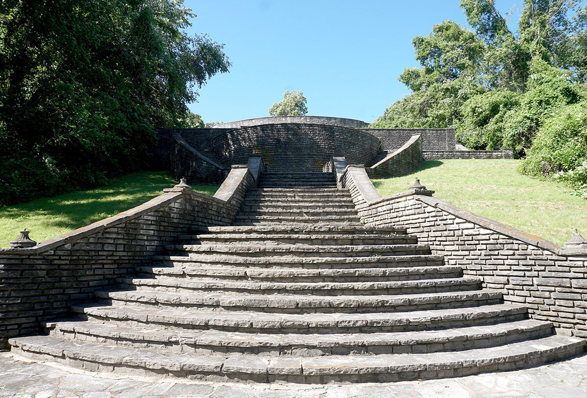
After the military left, the land passed through various hands for more than a century. In the 1930s, President Franklin D. Roosevelt created the Works Progress Administration to construct public parks, bridges and other structures nationwide. Workers here built several limestone structures throughout Fort Belle Fontaine with the idea of turning the land into a riverside retreat.
They built a grand staircase, made of several terraces of stone steps leading down to the river. The basins and fountains that once dotted the tiers on the terraces are now dry. The WPA Orchestra performed on these steps in 1939 for a visiting Eleanor Roosevelt, and the boys who lived in the cottages on the property sang for her.
“The boys never had any time to weary of too much orchestral music, nor did they have to sit still too long, because periodically they rose and sang as loudly as they wanted,” she wrote. “It seemed to me a very well-planned entertainment.”
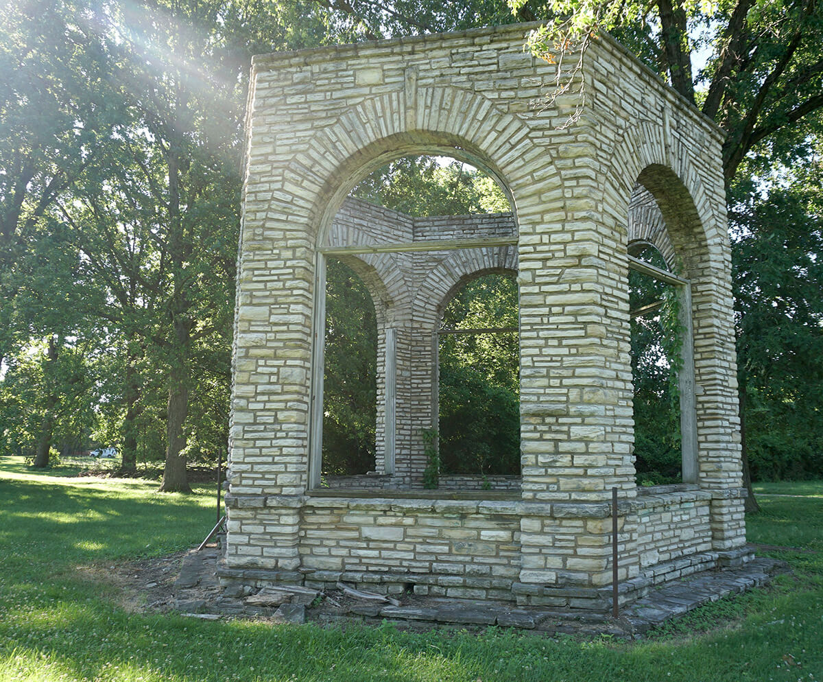
Location #9
Bath houses and outdoor living room

Go down the steps of the stone staircase and turn left, and not far down the path you’ll find two major areas with WPA constructions: two bath houses with pillars that once supported a concession area, and an outdoor living room with two barbecue fireplaces and a bench surround, along with a fountain where water once cascaded over rocks and into a reflecting pool. Park employees still build fires here during organized hayrides in the autumn. There are other stone structures from this era throughout the park, like a barrel-vaulted archway, fireplaces and a gazebo near the stone house at the top of the bluff. The structures have crumbled over the years and the Friends of Fort Belle Fontaine Park has worked with county officials to stabilize them and provide park programming.
1
2
3
4
5
6
7
8
9